Although it doesn't look like it at first glance, sailing and running have a lot in common. The combination of these two activities is attracting more and more new fans. Become one of them and get inspired by the tips for running routes below.
We recently introduced you to the specifics of running in Croatia and today we have a suggestion for three beautiful running routes. The first one is open to everyone and should be mastered by anyone who has done at least some running experience. The second one is very variable. You can run a few kilometres along a nice cycle path or spice up your running trip from the boat with a run up the highest hill of the island of Krk. The third route is for connoisseurs. You can make the run to the highest hill of Rab more enjoyable by sitting in a fabulous pub with a kitschily beautiful view.
1. Zaton-Nin, black mud, white salt, salty ice cream
Easy, relaxing route
Difficulty: suitable for beginners and enjoyers
Terrain: flat, largely asphalt or pavement, partly gravel
Total length: 10 km (Zaton-Nin-Zaton), 12 km (with a detour to the Salt Museum)
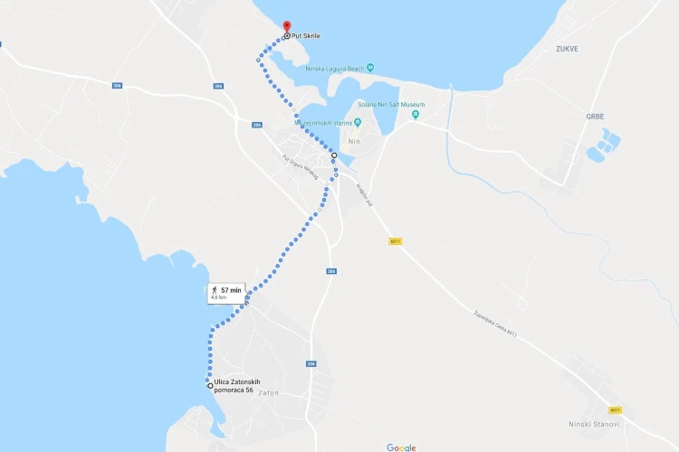 The route from Zaton to the mud wraps is five kilometres long
You will probably also find yourself close to the mainland during your trip, specifically the city of Zadar. The proposed route can thus be a sporty, non-yachting activity at the beginning of your stay, or at the end, when you will inevitably start to get closer to solid ground.
The route can also be taken from Zadar towards Zaton (add another 15 km in one direction), but as there are several kilometres of unpleasantly busy road to avoid, we recommend this option only for the more hardy and persistent fans of running.
It is much more convenient to land in Zaton and from the deck of the boat head first along the coast towards the north and then directly to Nin. The route also includes about a kilometre of such more industrial territory, but fortunately only by sight, the traffic is almost nil. Ideally, the road to the northeast will bring us just before the ancient bridge to the Nin peninsula. We skip this for a start and continue along the coast and the town mooring towards the Ninska Laguna campsite. However, we do not turn off the road and continue straight on until we almost reach the sister campsite Ninska Laguna 2. There is a dirt road leading to it, we will follow the better maintained one, turning directly east, towards the sea. The road will be paved with rafts, by which we will clearly know that we are there.
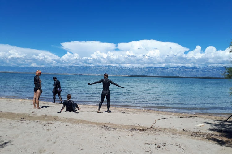 The Czechs are fond of healing mud.
The area is marshy, with shallow pools, rather large puddles full of black, supposedly healing mud. It's also possible that the rumour of its healing powers was spread by mischievous natives, who then only watch from afar amusedly confused Czech tourists, how they jumped on their toes. But even if it's not curative, it's fun, all the same! The correct procedure is said to be as follows: pour black mud on yourself from head to toe and let it dry completely in the sun. Then, in the sea bay of Ninski Zaljev, you can wash the substance off with a vigorous swearing. It is supposed to be refreshing especially for the skin, joints and overworked muscles.
YACHTING.COM TIP: The small and picturesque town of Nin. The ancient Romans left behind the ruins of interesting and at the time very important monuments. In the 7th century Nin was even the cultural centre of Croatia. The coronation ceremonies of Croatian rulers were held here. Among other things, the smallest cathedral in the world, the Church of the Holy Cross (Crkva svetoga Križa) from the early 9th century, is worthy of attention.
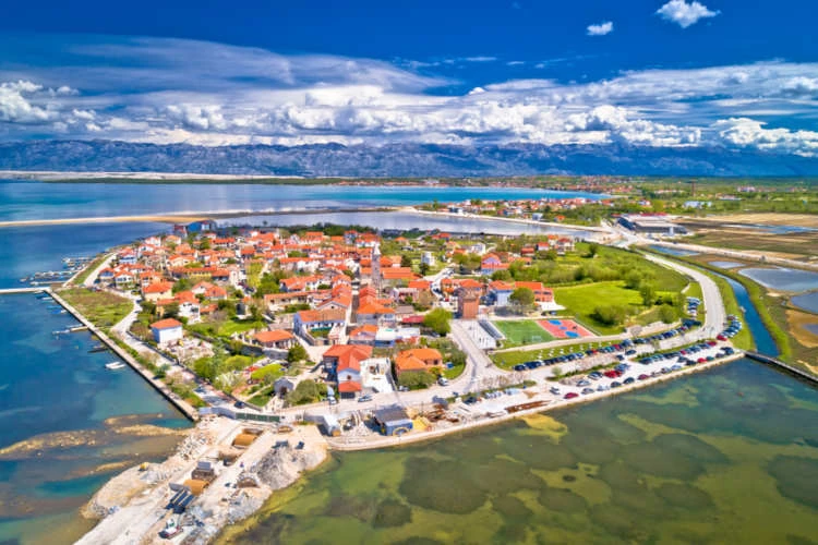 The unique town of Nin is worth a trip
The trail from Zaton to the marsh is exactly 5 kilometres long. When returning along the same route, be sure to pop over to the fortified (semi-)island of Nin after about 2 kilometres. It is three-quarters protected by the sea, the remaining quarter by a marsh. However, there are two bridges leading to it and the visit is definitely worth it. Ironically, most attacks will have to be fended off from inside the fortified island town, where you'll be assaulted by countless charming cafes, pubs and ice cream parlours. Even lovers of ancient monuments will be in for a treat.
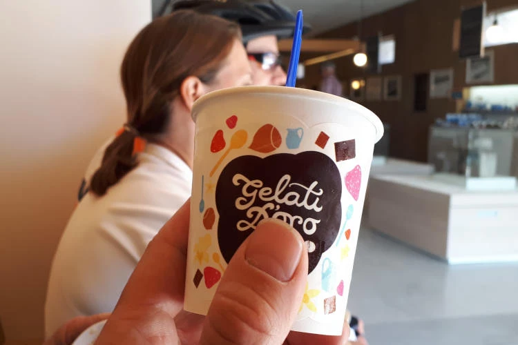 Salty ice cream is worth the mile-long detour
If you still have a taste for discovery, head north-east from Nin along road 6004 for about a kilometre. There you will find the Salt Museum. In the gift shop, you can buy a plethora of different packs of variousand refresh yourself with a truly sumptuous local specialty - salty ice cream.
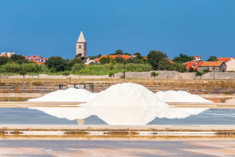 Nin has a long tradition of salt mining
YACHTING.COM TIP: The local salt was brought to the table by Roman emperors, and the Romans paid their soldiers in this mineral when salt was equivalent to gold. By the way, did you know that such a salary was called salarium and that this is the origin of the current English word for salary "salary"?
Krk - Punat (and three peaks)
Easy to very difficult route
Difficulty: something for peak conquerors, but also for café loafers
Terrain: slightly undulating (7 km between Krk and Punat; easy option), on unpaved mountain paths, steep in places (from Punat to the mountains and back; very difficult option)
Total length: 7 km (Krk-Punat), 28 km (Krk-Punat-three peaks-Punat-Krk)
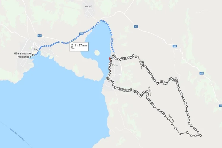 The easy route from Krk to Punat is marked in blue, the addition for experts in black
 If you decide to visit the northernmost of the large Croatian islands and you manage to dock in the town of the same name, Krk, then you will not want to miss the opportunity to go for a good run. Through the historic centre , we will head up to the northeast and follow the main road (Ulica Narodnog Preporoda) to the D102, which we will only crossto get onto a pretty fancy cycle path that basically takes you all the way to the next port town , Punat. Here our running odyssey could actually end(after 7 km with beautiful views, slightly undulating terrain), for example in a local restaurant. This is the easy option.
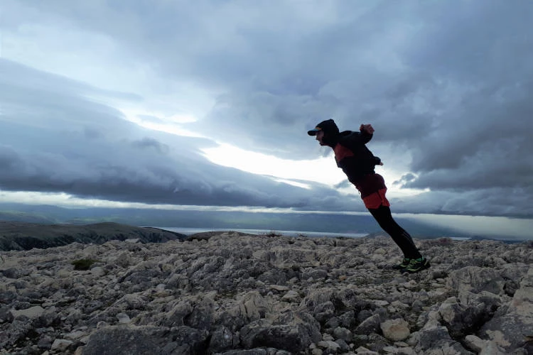 It's really windy at the top of Obzova
Lovers of extremes don't stop at the tempting seaside town and continue steadily further up. Turn left off the main road, almost due east. A signpost will point to the cross road, which we will also take. But we will carry our running cross much further across the contours. As soon as the rough gravel path joins the better paved path, continue right on the worse one. The originally easterly direction begins to turn southeast. At about 300 metres we reach a cycle path, soon to turn left again further up. Nothing better than broken stone paths await us from now on. At a fork in the road where the gradient begins to ease somewhat and the road straightens out, we turn sharply south and cut through the rocks to the ridge.
 There is no easy path to the top of Obzova
The first peak we come across is Veli Vrh (541 m above sea level). But it will still leave us cold, because we can already see Brestovica ( 558 m) and Obzova (569 m), the highest peak of the island. We once christened it the more pejorative "Kobzola" because it gave us wind gusts of over 100 km/h. We were still happy to take the poorly defined retreating western route, which gradually turns to the northwest.so that it could run perpendicular to the contours and join forces with the MTB5 mapped cycle path on its last third.2. We agreed at the time that if this is a cycle path, then it is intended exclusively for insane suicides. If you're lucky and one of the crew picks you up with the boat in Punat, you're done with your trail once you return to this town. Then if you return to Krk, you have another 7 km to go, for a total of 28 km.
What other activities can you combine with sailing?
Rab-Kamenjak-Rab
Moderately difficult route
Difficulty: up to the basics! Something for gourmets, beer drinkers and hill lovers
Terrain: challengingly steep in the first half, pleasant but also challenging in places, downhill in the second half
Total length: 13 km (6 km on the way up, 7 km on the way down with a detour to the restaurant)
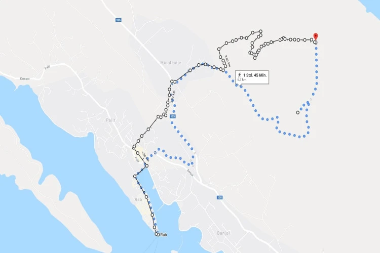 The way up is marked in black, the way down in blue with a clear turn to a picturesque restaurant
If you ever find yourself on the island of Rab, or in the marina of its eponymous capital, don't hesitate to make a great outing not only with the amazing views of theviews of the sea, decorated here and there with white triangles of stretched yacht sails, but also a fresh sea breeze and a climb to the highest peak of the island. All this spiced up by a stay in the garden of a pub so terribly kitsch you'll fall in love with it.
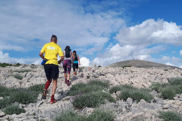
It's here on the island of Rab that you can smell the ancient roots of the human race. The proto-human also ran, but not like us. He didn't run for fun, he ran because he had to. He was running after food that was running away from him, or he was running away from a predator to avoid becoming food himself. As a reward, nature gave him some endorphins, the hormones of happiness, and in the first case, a full belly.
 The road to Kamenjak is certainly not the easiest.
And it is the first case, the very foundation of running motivation, that you can try on the way to Kamenjak . You leave all the conveniences of civilisation behind to tackle a steep hill on ever-worsening roads, even off-roads at the top. Reaching the summit will only be the beginning of the better moments.
 The spit from Kamenjak was definitely worth the effort.
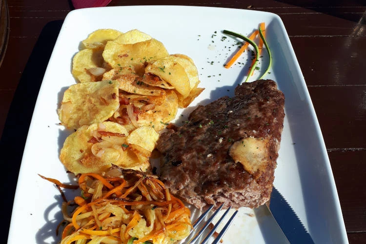
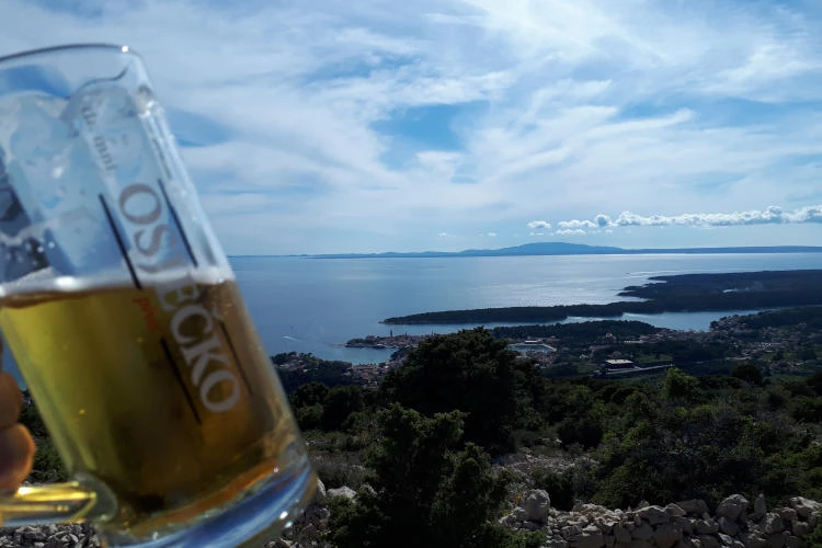
The route from Rab to Rab via Kamenjak is ideal in yet another direction. First a lot of hard work - 5 kilometres almost constantly uphill, culminating in the summit and then just a sweet, sweet six-kilometre run with great views, which you can definitely make more interesting with a small detour to the Kamenjak restaurant with a great viewing terrace. The traditional plieskavica there was the best of all Croatia. Although the Šviháka waiter did not have it listed on the menu, he responded promptly to the inquisitive inquiries of our Czech friends: No problem! We wish you could see the sparkle of his draft beer with the background of the setting sun over the sea... We all carried that sparkle in our eyes all the way back down to the boat.
 Spark in the eye, wind in the sails!
Would you like to rent a boat? No problem, contact me and we'll work it out together.